INTRODUCTION:
 The winter dredge survey is the only bay-wide fishery independent effort to estimate the number of blue crabs living in the Chesapeake Bay. The winter dredge survey produces information that is essential for the management of the species, such as an estimate of the number of crabs over-wintering in the bay and the number of young crabs entering the population each year. Also calculated is the estimated number of females that could spawn within the year, which is an important indicator of future spawning potential. Estimating the total number of crabs living in the bay allows us to calculate the percentage of the crab population that is removed by harvest each year. A pilot version of the winter dredge survey was first conducted in 1988 with the cooperation of the University of Maryland Chesapeake Biological Lab. In 1989 the Virginia Institute of Marine Science joined the survey, and the two states continue to sample each winter from December through March.
WHERE WE SAMPLE:
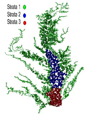
 Since 1994, the survey has been conducted according to a stratified random design (Rothschild and Sharov, 1996). The bay is divided into three regions or strata: Lower Bay (the mouth of the Chesapeake to Windmill Point, VA), Middle Bay (Windmill Point, VA to Cove Point, MD) and the Upper Bay/Tributaries (Cove Point to Pooles Island and all of the Bay's tributaries). Each year, a total of 1500 sites in waters deeper than 5 feet are randomly selected. The number of sites assigned in each region is proportional to its area.
HOW WE SAMPLE:
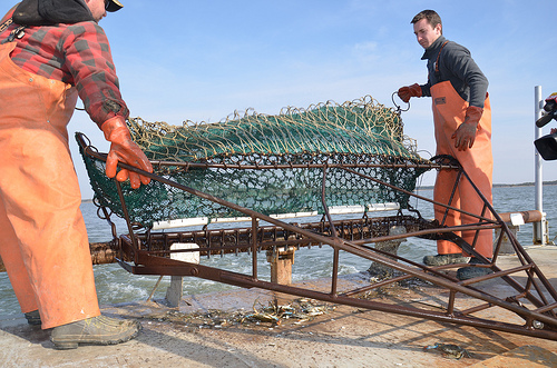
A six-foot-wide Virginia crab dredge fitted with a half inch nylon mesh liner is towed along the bottom for one minute at a speed of three knots. Latitude and longitude, measured with a Differential Global Positioning System (GPS), is recorded at the beginning and end of each tow to determine distance covered. This distance is multiplied by the dredge's width to calculate the area covered. Beginning and ending depth, water temperature, and salinity are recorded at each site.

3 comments:
We are supposed to believe these dumbasses at DNR when the Peoples Republic of Md can't even tell you how many illegal aliens are in the state. Anything they say - its usually the opposite. If they are wrong they want to regulate more. If they are right they take credit as if they were responsible. The state would take credit for the sun coming up if they thought we were stupid enough to believe it
920 if you dont have the science chops to actually challenge/debate their work, sit back and enjoy a coke and a smile. Let the adults handle this one. You illustrate one of the biggest problems we have in this country. Yeah you may have a right to have an opinion. That doesnt mean the world needs to hear the uninformed uneducated garbage being spewed from your mouth.
Uh Oh, I think 7:44 has a gov't job.
Post a Comment