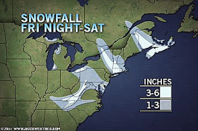
Suddenly Delmarva and many neighboring areas are becoming quite the rage as far as snow is concerned.
A disturbance rolling in from the Midwest will spark another round of snow in the eastern mid-Atlantic late tonight into Saturday.
The same system may gel fast enough to bring the Baltimore/Washington area a coating to an inch of snow as well. While most non-weather weenies in this area are not exactly waiting in line for their first real snowfall, the snow nuts have become quite feverish about the lack of snow so far.
Pretty much anybody in the Northeast is fair game for a sneak attack from a coating of snow into Sunday.
AccuWeather.com meteorologists continue to monitor a potentially big storm for next week. That storm may visit the mid-Atlantic and other East Coast locations with heavy snow or perhaps a wintry mix long about Tuesday, depending on the storm track.
According to Chief Meteorologist Elliot Abrams, "While the main storm next week is likely to bring the heaviest precipitation along the coast, a trailing feature over the Midwest could allow snow to fall in areas west of the I-95 corridor as well."
Current thinking says the precip could include a rain/sleet/snow mix, or maybe not, depending on the track and temps.
But COLD weather is coming behind the system next week, so there could be icing and very slick roads to deal with.
We're on it for you. Stay tuned.
More at Accuweather


Anything is better than the local yokels.
ReplyDeletebe sure to buy up all the milk and bread paranoid people.
ReplyDeleteYou forgot toilet paper.
ReplyDelete